We were driving back from Diu to Ahmedabad after a short family vacation.
Nothing fancy.
No rush.
Google Maps said 6 hours.
It felt reasonable. We packed snacks, filled the tank, and started early. Confidence level? High.
By the end of the day, that 6-hour trip quietly turned into 9 hours, and not because of traffic.
When “Shortest Route” Becomes the Worst Route
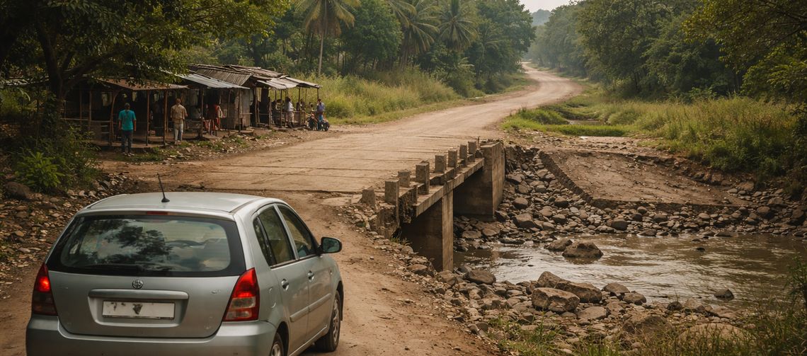
Somewhere along the way, Google Maps decided to “optimise” the journey.
Not the fastest route.
Not the safest route.
The shortest route.
The highway slowly disappeared.
The road narrowed.
Villages appeared, one after another.
At one point, Google confidently said, “Continue straight.”
There was no bridge.
Just a dried river bed.
We actually drove through it.
That’s when it hit me:
Technology doesn’t know what’s usable.
It only knows what’s possible.
How Google Maps Actually Calculates ETA
This is something most people don’t realise.
Google Maps ETA is calculated using:
- Historical traffic data
- Live traffic (when available)
- Assumed average speeds for each road type
Rough assumptions look like this:
- Highways: 80–90 km/h
- State roads: 50–60 km/h
- City roads: 20–30 km/h
What it doesn’t fully account for:
- Poor road conditions
- Missing infrastructure (like bridges)
- Narrow village roads
- Family travel pace
- Food, fuel, and washroom breaks
That 6-hour ETA already assumed continuous movement with minimal interruptions.
On Indian roads, that’s optimistic at best.
Why Vehicle Type Matters (And Why Google Ignores It)
Google Maps lets you choose:
- Car
- Motorbike
- Cycle
- Walk
- Train
What it doesn’t offer:
- Mini Bus
- Bus
- or any large passenger vehicles
This matters more than people think.
Larger vehicles:
- Need wider roads
- Avoid tight village shortcuts
- Choose longer but safer routes
A route that works for a car may be completely impractical for a bus.
On this trip, that difference became painfully clear.
The Turning Point: Asking People Instead of Screens
After the river-bed incident, I stopped following the map blindly.
At tea stalls.
At fuel pumps.
At random crossings.
Every local suggested a better route.
Not one of them recommended what Google Maps had chosen.
Why Breaks Change Everything
That’s when I stopped thinking in terms of ETA
and started thinking in terms of real travel time.
Real travel time =
Driving time + Breaks + Delays
Breaks aren’t optional.
They’re part of the journey, especially when travelling with family.
How I Estimate Travel Time Now
Before road trips, now I:
- Look at the total distance
- Assume a realistic average speed
- Add planned breaks
I calculate it myself, not to replace Google Maps, but to sanity-check it.
You can try estimating your own road trip time below.
Road Trip Time Estimator
| Distance | ||
| Avg Speed | ||
| Breaks |
The Bigger Lesson This Trip Taught Me
This trip wasn’t just about roads.
When the app failed, something unexpected happened:
I learned how to read physical maps again.
Yes, they’re still available.
At a roadside stop, someone unfolded an old paper map and explained the route with a finger. No zooming. No rerouting. Just landmarks and logic.
That moment reminded me:
- Digital maps show possibilities
- Physical maps show perspective
I still use Google Maps, but now I trust my judgment, local advice, and sometimes even a folded piece of paper.
Have You Faced Something Similar?
I’m sure I’m not the only one who’s been confidently led into the wrong route by a blue line on a screen.
Have you ever:
- Taken a “shortcut” that wasn’t a shortcut?
- Ended up on roads that barely qualified as roads?
- Ignored Google Maps and trusted a local instead?
Or maybe you completely disagree.
I’d love to hear your experience or thoughts in the comments.
Final Thought
I still use Google Maps.
I just don’t worship it anymore.
Now I plan loosely, calculate realistically, ask people, and stay open.
Because not every journey needs perfect planning.
Sometimes, you just start, and figure things out along the way.